K&P Trail
K&P Trail
The waterfront pathway and K&P Trail remain open. Residents who use City trails are urged to practice physical distancing. View the latest updates on the COVID-19 situation in Kingston, including impacts to City facilities, programs, and services.
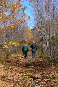
The K&P Trail offers both an off-road and on-road route for recreation and active transportation. It is open year round, offering a range of scenic experiences through natural open landscapes, rock cuts, wetlands and historic Kingston. The abandoned rail bed was converted into a multi-use trail for walkers and non-motorized vehicles.
The K&P Trail within the City of Kingston is 22 km long and made up of 2 distinct sections:
- The urban K&P Trail pathway section is 7 km long. This pathway is paved and starts at Confederation Park and connects north to the Binnington Court access point.
- The rural section of the K&P Trail in Kingston, is 15 km long. This trail is gravel and runs from Binnington Court northwest to Orser Rd.
- North of Orser Road, the trail extends into Frontenac County and will ultimately connect to Sharbot Lake 58 km beyond the Kingston boundary. Some sections of the trail in Frontenac are still under development.
Full Trail Map
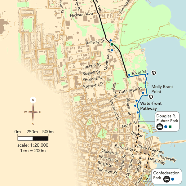
Download the full trail map.
Urban K&P Trail
- This 7 km stretch of pathway is a mix of both on and off road routing.
- The pathway is completely paved (asphalt or concrete) and is 3 m wide except for the on road section at Division St., River St. and John Counter Blvd.
- The trail can be accessed from many locations including Confederation Park, Douglas R. Fluhrer Park, Belle Park, Montreal St. (at Railway St.), Division St. (opposite Weller Ave.), Dalton Ave (at St. Remy Pl.), and Binnington Court (at west terminus of Dalton Ave.).
- The pathway coincides with the City of Kingston‘s waterfront walkway from Confederation Park to River St.
- The pathway opened in 2017.
Rural K&P Trail
- The 15 kilometre trail surface is gravel and stone dust.
- The trail can be accessed from many locations including Binnington Court (at west terminus of Dalton Ave.), Sydenham Rd. (south of Hwy. 401), McIvor Rd. (0.7km east of Hwy #38), Burbrook Rd. (at Jackson Mills Rd. and Cordukes Rd.), Unity Rd. (2.4km east of Hwy #38) and at Orser Rd. (1.5km east of Hwy #38). North of Orser Rd. The trail continues into South Frontenac Township.
- This scenic section of the trail climbs bluffs and escarpment, passes wetlands and man-made ravines. It runs adjacent to farmers' fields and an historic mill.
- Parking can be found at Binnington Court, McIvor Rd., Burbrook Rd. (at Cordukes Rd.) and Unity Rd.
- The trail continues through South and Central Frontenac on rural (granular) trails.