
Bayridge Drive Cycling & Pedestrian Improvements
Bayridge Drive Cycling & Pedestrian Improvements
About the Project
On this page
- Background
- What’s Changing?
- Project Overview Map
- What this Project Means to You
- Project Renderings
- Connections to Other Cycling Routes
- Public Engagement
Background
Improvements to Kingston’s cycling network are planned along Bayridge Drive between Henderson Boulevard and Cataraqui Woods Drive to make the route safer for pedestrians, cyclists and drivers. It will create a new route for active transportation modes, such as pedestrians and cyclists. The route along Bayridge Drive features connected off-road cycling facilities (designated routes for bikes) and will create a single protected route for cyclists of all ages and abilities and safer travel options for pedestrians.
This particular corridor was first identified as a core route in the City’s Active Transportation Master Plan (ATMP). That plan provides a high-level view of the city’s cycling infrastructure system and looks at how to improve the City’s active transportation network for cyclists and pedestrians. From the ATMP, a five-year work plan was developed, the Active Transportation Implementation Plan 2019-2023 (ATIP), which identified a portion of Bayridge as a major priority to build, as part of Route 6.
Federal funding from the Investing in Canada Infrastructure Program was also awarded to the City of Kingston, specifically to help improve pedestrian, cycling connections and transit access. Thanks to that support we have been able to expand the project to improve the experience for everyone who travels along this route.
Once completed, a portion of this route, from Coverdale to Henderson, will also form part of the Great Lakes Trail.
What’s Changing on Bayridge?
The most significant change will be the option for off road, protected cycling infrastructure along Bayridge Drive between Henderson Boulevard and Cataraqui Woods Drive, including intersection safety upgrades.
Cycling Route
Currently, the only cycling options on this stretch of Bayridge are on the road and unprotected. The new off road bike facilities will provide options for those who would like to use cycling as a means of transportation but are concerned about riding on the road by reducing the risk of interaction between drivers and cyclists. While on-road cycling options will remain, we will be installing connected off road cycling facilities to create a continuous protected route for cyclists of all ages and abilities.
All bike facilities are being designed in line with the most recent update of Ontario Traffic Manual 18 – Bikeway Design Guidelines.
Intersections
Upgrades to intersections will include marked crossings and bike signals at all signalized intersections. To improve pedestrian safety we will be reviewing lane configurations, turning space, marked crosswalks, traffic signal heads and signal timings to ensure that intersections are safer for pedestrians of all ages and abilities.
Project Overview Map
The map below outlines how these different cycling facilities and intersections will connect to form a continuous route.
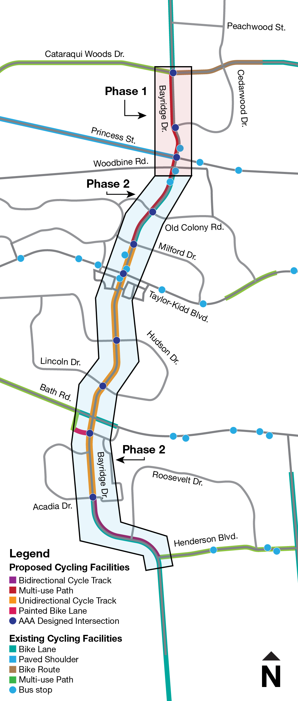
View an enlarged version of the map.
The map highlights the type and extent of cycling facilities being implemented along the corridor as part of this project.
From the south, a bidirectional cycle track will run from Henderson Boulevard to Acadia Drive where through intersection design it will transition to unidirectional cycle tracks on either side of Bayridge Drive. These continue to Milford Drive where it transitions at the intersection to a multi-use path that continues north to Cataraqui Woods Drive.
What this project means to you
Pedestrians
We are adding sidewalks or multi-use pathways along the corridor where no pedestrian routes currently exist to make it easier and safer walk along Bayridge Drive. We are reducing the need to cross the road as frequently and improving intersections that will make it safer for pedestrians to cross and slow down turning vehicles.
Cyclists
We are building off-road cycling options along Bayridge Drive between Henderson Boulevard and Cataraqui Woods Drive that can be used by all ages and abilities. Intersections will be redesigned to prioritize bikes by adding dedicated bike cross rides and bike signals. This will make commuting and recreational trips along the route safer and more enjoyable for all levels of cyclists.
To learn more about the different types of cycling facilities Kingston uses visit our Cycling Infrastructure page.
Transit Users
This project will also help to improve cyclist and pedestrian connections to existing local and express transit services along Bayridge Drive, which will make it safer and easier to use transit as part of your journey.
Drivers
You can expect to see some new features along the roadway that will reduce conflict points and make cyclists and pedestrians more visible at intersections, including green painted cross rides and bike signals at intersections.
A southbound travel lane, between Hudson and Lincoln Drive, will be removed, while between Lincoln and Coverdale Drive a travel lane in both directions will be removed. The removal of these travel lanes will provide space for the off road bike route and extend walking facilities along the east side of the overpass between Lincoln and Coverdale. In preparation for this project we have completed a traffic impact study along this route and don’t anticipate any significant traffic impacts related to these required lane reductions.
To learn more about the different types of cycling facilities Kingston uses visit our Cycling Infrastructure page.
Project Renderings
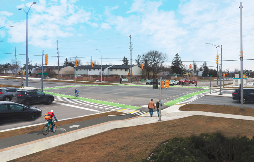
Rendering of Taylor Kidd and Bayridge intersection showing protected intersection features to make it safer and more comfortable for people cycling and walking. These include cross rides, dedicated space in the corner and bicycle signals.
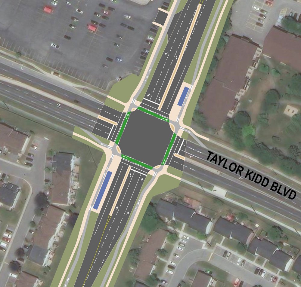
Plan view of the proposed design for Bayridge and Taylor Kidd Intersection, showing cycle tracks, cross rides, bicycle queuing space, and island bus platforms.
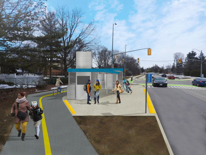
Rendering at Old Colony Road shows a multi-use pathway for people walking and cycling and a bus platform between the multi-use pathway and the roadway.
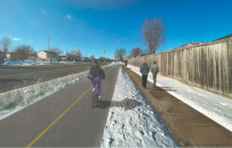
Rendering south of Acadia Drive shows a bidirectional cycle track and sidewalk on the east side of Bayridge Drive.
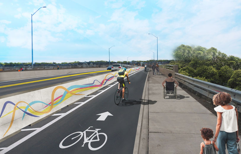
Rendering of Bayridge Drive overpass over Bath Road showing cycling facility separated by a barrier. The barrier could be used as an opportunity for public artwork.
Connections to Other Cycling Routes
We are working to build a city-wide connected cycling network, the Bayridge route, named Route 6, is an integral part of that connected network.
Once complete, Route 6 will connect with the following pre-existing routes:
- Bath Road multi-use pathway from Collins Bay Road to Coverdale Drive.
- Henderson Boulevard multi-use pathway between Bayridge Drive and Days Road.
- Cataraqui Wood Drive on-road bike lanes and multi-use pathways.
- Bayridge Drive on-road bike lanes north of Cataraqui Woods Drive or south of Henderson Boulevard.
- A portion of the project from Coverdale to Henderson is part of the Great Lakes waterfront trail.
This project will also connect with some routes that will be built in the future including:
- Future cycling facilities planned for Taylor Kidd Boulevard
- Future cycling facilities planned for Princess Street
Public Engagement
A public open house was held in May 2022, regarding the Bayridge Drive Cycling and Pedestrian Improvements. Watch a video of the open house.
-
May 2021
Report to council on AT improvement opportunity -
Fall 2021 - Spring 2022
Develop design -
Spring 2022
Public consultation -
Summer 2022
Finalize design -
Fall 2022 – Fall 2023
Tender -
2023-2024
Construction on phase one began in spring 2023, construction will continue in 2024 with phase two.