Neighbourhood Road Safety
Neighbourhood Road Safety
On this page
- Community Safety Zones
- Rollout of Community Safety Zones
- Neighbourhood Area Speed Limits
- Completed Neighbourhood and School Area Pilots
Reducing vehicle speeds improves safety for all road users. Neighbourhood Area Speed Limits can help set consistent expectations for motorists across a community, encouraging careful and cautious driving through the area. Community Safety Zones also help to reinforce safe and attentive driving, especially in school areas where families may be walking or cycling to school.
Speed limit reductions and Community Safety Zones are being implemented in a phased approach to allow monitoring and evaluation of the programs.
In two pilot areas – Westwoods and Strathcona Park – the City has introduced neighbourhood-wide Area Speed Limit reductions to 40 km/h, school area speed limit reductions to 30 km/h, and the introduction of Community Safety Zones in the immediate area surrounding schools.
Community Safety Zones are also planned to be introduced at all schools in Kingston.
Community Safety Zones
Community Safety Zones are a distinct regulatory tool from posted speed limits and are intended to remind motorists that they are driving in an area with higher volumes of pedestrians and vulnerable road users, such as near schools. Community Safety Zones encourage individuals to slow down and drive with increased care.
The rules of the road for driving do not change within a Community Safety Zone. However, the fines for many traffic violations, including for speeding, are doubled within Community Safety Zones to encourage safe driving and to improve compliance with posted speed limits.
In Kingston, Community Safety Zones are being installed at all schools in Kingston to improve driver awareness of the presence of pedestrians in proximity to schools and encouraging safer driving in these priority areas.

City-wide rollout: Fall 2022 – Fall 2023
Community Safety Zones (CSZs) will be introduced at all schools in Kingston by the Fall of 2023. This will provide consistent messaging to motorists at schools citywide and allows for enhanced enforcement in these priority areas.
View the full Neighbourhood Community Safety Zones map.
In order to meet the City’s target of implementing CSZs at 50+ schools by Fall 2023, the associated planning, design, field investigation, communications, and installation work will be carried out in three rounds, with Round 1 installations scheduled for Fall 2022. Planning and design work will continue through the winter, allowing for the Round 2 CSZ installations to be completed in Spring-Summer 2023, and Round 3 installations in Summer-Fall 2023.
CSZs will be introduced at the following schools in Round 1 (Fall 2022):
- Central Public School
- École élémentaire catholique Mgr-Rémi-Gaulin
- École Maple Elementary School (formerly École Kingston East Elementary School)
- Elginburg Public School
- J.G. Simcoe Public School
- Joyceville Public School
- Polson Park Public School
- R.G. Sinclair Public School
- Rideau Heights Public School
- St. Francis of Assisi Catholic School
- St. John XXIII Catholic School
- St. Marguerite Bourgeoys Catholic School
- St. Martha Catholic School
- Truedell Public School
- W.J. Holsgrove Public School
Round 2 CSZ installations, scheduled for Spring-Summer 2023, tentatively include the following schools:
- Archbishop O'Sullivan Catholic School
- Bayridge Public School
- Bayridge Secondary School
- Calvin Park Public School
- Cataraqui Woods Elementary School
- Centennial Public School
- École catholique Cathédrale
- Frontenac Secondary School & Module de l'Acadie
- Glenburnie Public School
- Holy Name Catholic School
- J.R. Henderson Public School
- Kingston Secondary School & Module Vanier
- La Salle Intermediate & Secondary School
- Loyalist Collegiate & Vocational Institute (LCVI)
- Molly Brant Elementary School
- Our Lady of Lourdes Catholic School
- St. Thomas More Catholic School
Round 3 CSZ installations, scheduled for Summer-Fall 2023, tentatively include the following schools:
- Collins Bay Public School
- École élémentaire publique Madeleine-de-Roybon
- École Rideau Public School
- École secondaire catholique Marie-Rivier
- École secondaire publique Mille-Îles
- King's Town School
- Leahurst College
- Mulberry Waldorf School
- Quintilian School
- Regiopolis-Notre Dame Catholic High School
- Sydenham Public School
- Welborne Avenue Public School
- Winston Churchill Public School
![]()
This project is funded in part by the Government of Canada.
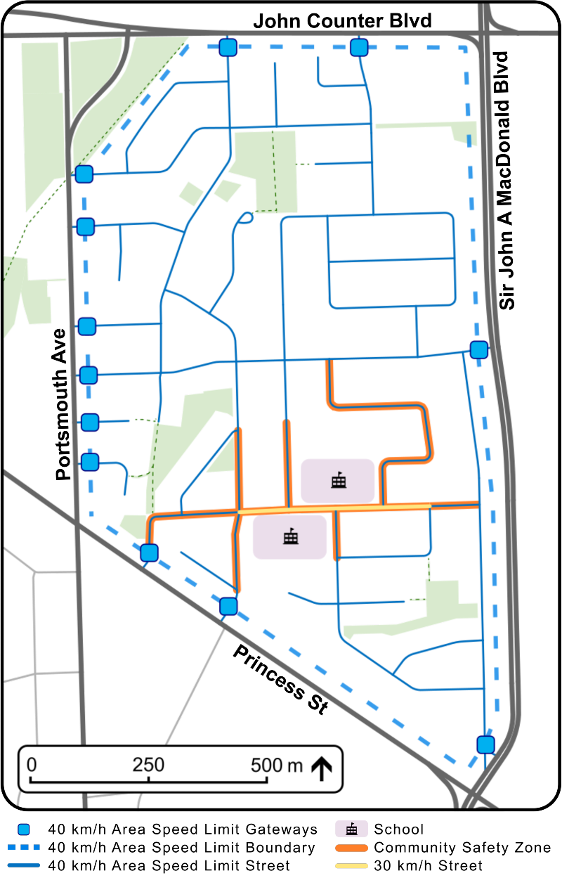
Neighbourhood Area Speed Limits
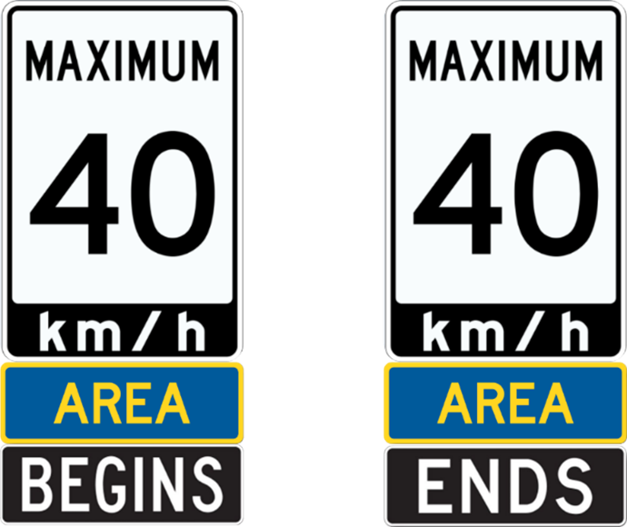
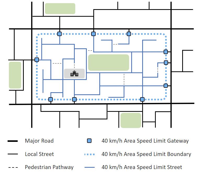
Neighbourhood Area Speed Limits are zones where the speed limit has been reduced to 40 km/h for all roads within that designated area, unless posted otherwise. These areas have gateway speed limit signage installed at all entry and exit points to and from the bordering main roads. This signage includes ‘AREA’ and ‘BEGINS’ or ‘ENDS’ tabs below the posted speed limit. The existing speed limits on main roadways bordering the designated area are not affected.
A conceptual map illustrating how Area Speed Limits can be applied is shown below.
Neighbourhood and School Area Pilots: Completed Summer 2022
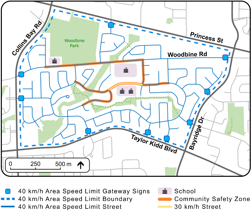
The first phase was introduced in advance of the 2022/2023 school year and involved pilot projects in the Westwoods and Strathcona Park neighbourhoods. Within the two pilot neighbourhoods, Area Speed Limits reduced the speed limit on local streets to 40 km/h, the school area speed limit was reduced to 30 km/h, and Community Safety Zones were introduced in the immediate area surrounding schools.
Westwoods
In the Westwoods neighbourhood, a speed limit of 40 km/h applies to all streets bounded by Princess Street to the north, Bayridge Drive to the east, Taylor Kidd Boulevard to the south, and Collins Bay Road to the west. An additional speed limit reduction to 30 km/h applies along the school frontages on Lancaster Drive. A Community Safety Zone surrounding the schools encourages safe driving and allows for enhanced enforcement with increased fines for speeding.
Strathcona Park
In the Strathcona Park neighbourhood, a speed limit of 40 km/h applies to all streets bounded by John Counter Boulevard to the north, Sir John A. MacDonald Boulevard to the east, Princess Street to the south, and Portsmouth Avenue to the west. An additional speed limit reduction to 30 km/h applies along the school frontages on McMahon Avenue. A Community Safety Zone surrounding the schools encourages safe driving and allows for enhanced enforcement with increased fines for speeding.
Future Work
Monitoring and evaluation of the Neighbourhood pilot projects and the assessments undertaken for the implementation of Community Safety Zones at all schools will inform future expansion opportunities of the speed limit reduction principles to other locations throughout the city, where appropriate.