Downtown Action Plan
Downtown Action Plan
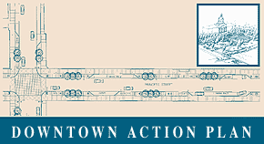
The Downtown Action Plan (DAP) was approved in principle by City Council in September 2004. The Downtown Action Plan is an infrastructure and urban design study for the entire downtown. The Plan came from the need to replace the underground utility infrastructure (storm and sanitary sewers, waterlines, electrical, telecommunications and fibre optics) in the Downtown area.
The plan's study area consists of approximately thirty-six city blocks, and the project will involve the replacement of roughly nine kilometres of urban streets and sidewalks from building edge to building edge detailed in an annual work plan spread over multiple years.
In some sections, the underground utility infrastructure is 200 years old and has never been subject to a comprehensive underground infrastructure replacement program. Kingston is not unique in this regard, as deteriorated underground infrastructure is an issue in cities across Canada.
This comprehensive plan will:
- Direct increased green space and connections to the waterfront
- Coordinate streetscape improvements with the replacement of underground services
- Identify opportunities for tourism, recreation, and entertainment
- Improve traffic movement
While the study boundaries reflect the mixed-use downtown business district, the study identifies different character areas within the downtown. These are the Princess Street commercial streetscape, the Historic District between Brock and Johnson Streets, the redevelopment lands of the North Block and Block 'D' and, lastly, the Waterfront. The conceptual designs for Princess Street, the Historic District, Confederation Park, and Boucher Park and the Waterfront directed the development of layout patterns and a palette of streetscape elements for each of the character areas.
In order to encompass the physical character of the public open space, the study's scope includes lighting, public art, sidewalk cafes, signage, phasing, a financial plan and analysis of the closure of Ontario Street at Confederation Park. This presents a unique opportunity to co-ordinate various aspects of the public open space network into a complete vision. As a result, the plan will be useful in directing incremental changes and small projects, as well as, major projects staged over the next 10-15 years.
The design approach was based on three key concepts — clarify, complement and integrate. To a large extent, the aspect of clarification is based on the analysis of existing conditions, which resulted in the identification of four individual character areas within the downtown. The intent was to complement intrinsic qualities of each of the character areas. This resulted in recommendations for the arrangement of material palettes and elements as variations on a theme within the downtown. These recommendations are intended to enhance and work in harmony, rather than compete or distract from the existing heritage quality of the area. Similarly, the various streetscapes, parks and waterfront should be integrated, with the overall vision of supporting and improving the economic viability and quality of the downtown environment.